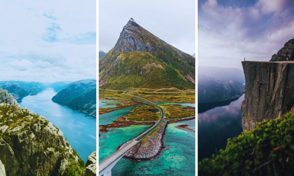
Norway, a country of stunning natural beauty, is a paradise for nature lovers and outdoor enthusiasts. Stretching from the southern tip of Scandinavia to the Arctic Circle and beyond, Norway offers an incredible variety of landscapes. From deep, dramatic fjords carved by ancient glaciers to rugged mountain peaks, lush forests to barren arctic tundra, the country is a showcase of nature’s grandeur.
In this comprehensive guide, we’ll explore the 10 most beautiful nature in Norway has to offer. Each of these locations presents a unique facet of Norway’s natural world, from the famous fjords to the magical Northern Lights. What makes each place special, when to visit, what to do, and practical tips to maximize your visit will be covered.
Whether you’re planning a trip to Norway or simply dreaming of far-off lands, this guide will take you on a journey through some of the most breathtaking scenery on Earth. So, pack your imagination (and maybe your hiking boots), and let’s explore the natural wonders of Norway.
1. Geirangerfjord
Geirangerfjord, located in the Sunnmøre region of Møre og Romsdal county, is often described as the jewel in the crown of the Norwegian fjords. Some of Norway’s steepest cliffs surround this S-shaped, 15-kilometer-long branch of the greater Storfjord (Great Fjord), creating a dramatic and awe-inspiring landscape.
Geological Formation
The last ice age formed Geirangerfjord, like most of Norway’s fjords. Massive glaciers carved out deep valleys, and when these glaciers retreated and sea levels rose, the valleys filled with seawater, creating the fjords we see today. This process took place over millions of years, resulting in the steep-sided, U-shaped valley characteristic of fjords.
UNESCO’s World Heritage Status
In 2005, UNESCO added the Geirangerfjord area to its prestigious World Heritage List, recognizing it as an area of exceptional natural beauty. The committee noted its “exceptional natural beauty and outstanding geological features,” highlighting it as one of the most scenically outstanding fjord areas on the planet.
Famous Waterfalls
Geirangerfjord is renowned for the numerous waterfalls cascading down its steep cliffs. The most famous of these are:
- Seven Sisters (De Syv Søstrene): This is the most photographed of Geirangerfjord’s waterfalls. It consists of seven separate streams falling from a height of about 250 meters (820 feet). The waterfall is at its most impressive in spring and early summer, when snowmelt increases the water volume.
- The Suitor (Friaren): Located directly across from the Seven Sisters, this waterfall gets its name from a local legend. Local legend describes it as “courting” the Seven Sisters, as its single stream appears to bow towards the seven streams opposite.
- The Bridal Veil (Brudesløret): This delicate waterfall is named for its resemblance to a thin, white veil. It’s particularly beautiful when the sun hits it at the right angle, creating rainbows in the mist.
Flora and fauna
Despite its steep cliffs, Geirangerfjord supports a diverse ecosystem.
- Plants: The area is home to a variety of plant species, including the rare Geirangerfjord hawkweed, which is found nowhere else in the world.
- Animals: Keep an eye out for seals, porpoises, and even the occasional whale in the fjord waters. On land, you might spot deer, foxes, and various bird species.
Ways to Experience Geirangerfjord
- Fjord Cruise: The most popular way to experience Geirangerfjord is by boat. Regular sightseeing cruises operate from April to October, offering close-up views of waterfalls and abandoned farms clinging to the cliffs.
- Kayaking: For a more intimate experience, consider kayaking on the fjord. A guided tour lets you paddle at your own pace and get closer to the waterfalls.
- Hiking: Several hiking trails offer stunning views of the fjord.
- Skageflå Farm Hike: A challenging hike to an abandoned farm perched on the cliffside.
- Waterfall Walk: An easier walk along the fjord, passing several smaller waterfalls.
- Scenic Drives:
- Eagle Road (Ørnevegen): This steep, winding road offers 11 hairpin turns and amazing views of the fjord.
- Trollstigen: While not directly on Geirangerfjord, this nearby mountain road is one of Norway’s most famous drives.
- Viewpoints:
- Flydalsjuvet: This viewpoint offers a classic postcard view of the fjord and Geiranger village.
- Ørnesvingen: The “Eagle’s Bend” viewpoint on the Eagle Road provides a sweeping vista of the entire fjord.
The Best Time to Visit
- Summer (June to August): This is peak tourist season with the warmest weather and longest daylight hours. However, it’s also the busiest and most expensive time.
- Spring (April to May) and Fall (September to October): These shoulder seasons offer fewer crowds and lower prices. The waterfalls are often at their most impressive in the spring due to snowmelt.
- Winter (November to March): Despite its beauty, many facilities remain closed, making navigation of the roads challenging. The fjord can freeze over in particularly cold winters.
Practical Tips
- Book accommodations and activities in advance, especially in the summer.
- Bring warm, waterproof clothing, even in the summer. The weather can change quickly in the fjords.
- If you are prone to motion sickness, consider taking medication before boat trips.
- Respect nature and follow Leave No Trace principles to help preserve this beautiful area for future generations.
Geirangerfjord truly embodies the raw beauty of Norway’s natural world. Its combination of towering cliffs, cascading waterfalls, and serene waters creates a landscape that seems almost too beautiful to be real. Whether you’re cruising its waters, hiking its trails, or simply gazing in awe from a viewpoint, Geirangerfjord offers an unforgettable experience of Norway’s majestic fjords.
2. Lofoten Islands
The Lofoten Islands, an archipelago in northern Norway, are renowned for their dramatic scenery, picturesque fishing villages, and rich wildlife. Located north of the Arctic Circle in the county of Nordland, these islands offer a unique blend of natural beauty and traditional Norwegian culture.
Geography and Geology
The Lofoten archipelago consists of seven main islands: Austvågøy, Gimsøy, Vestvågøy, Flakstadøy, Moskenesøy, Værøy, and Røst. These islands are the visible peaks of a massive mountain chain that extends far into the sea.
The landscape of Lofoten is characterized by:
- Steep mountains rise directly from the sea, with peaks reaching up to 1,000 meters (3,280 feet).
- Deep fjords cutting into the land
- The long, sandy beaches seem out of place in the Arctic.
- Small, sheltered bays with fishing villages nestled against the mountainsides
Various geological processes, such as volcanic activity, mountain building, and glacial erosion during the ice ages, formed the islands over millions of years.
Climate
Despite their location north of the Arctic Circle, the Lofoten Islands enjoy a relatively mild climate thanks to the Gulf Stream.
- Summer temperatures average around 12°C (54°F), but can reach up to 20°C (68°F).
- Winter temperatures hover around freezing, rarely dropping below -5°C (23°F).
- The islands receive substantial rainfall, contributing to their lush, green landscapes.
Wildlife
The Lofoten Islands are home to diverse wildlife.
- Sea Eagles: This area frequently hosts Europe’s largest eagle species.
- Whales: The surrounding waters are home to orcas, sperm whales, and humpback whales.
- Puffins: These charismatic seabirds nest on some of the outlying islands.
- The larger islands are home to Arctic foxes and moose.
Cultural Significance
For over 1,000 years, Lofoten has been a cod fishing center. The islands played a crucial role in Norway’s economy and culture.
- Dried cod, or stockfish, was a significant export that reached as far as southern Europe.
- The traditional fisherman’s cabin, or “rorbu,” is an iconic feature of Lofoten’s villages.
- The islands have inspired countless artists, writers, and photographers over the centuries.
Key Attractions and Activities
- Reine: Often called Norway’s most beautiful village, Reine offers stunning views of mountains reflected in calm waters.
- Henningsvær: Known as the “Venice of Lofoten,” this village spreads across several small islands connected by bridges.
- Hiking:
- Reinebringen: A challenging hike that offers panoramic views of Reine and the surrounding islands.
- Ryten: A moderate hike with views over Kvalvika Beach.
- Beaches:
- Haukland Beach: A long stretch of white sand with crystal-clear water
- Uttakleiv Beach: Famous for its “eye”-shaped rock formation
- Northern Lights viewing: From late September to mid-April, Lofoten is an excellent place to see the Aurora Borealis.
- Midnight Sun: From late May to mid-July, experience 24 hours of daylight.
- Surfing: Unstad Beach is a popular spot for Arctic surfing, with consistent waves year-round.
- Fishing: Join a sea fishing tour, or try your hand at traditional line fishing from the shore.
- Museums:
- Lofotr Viking Museum: Experience life in a reconstructed Viking longhouse.
- Norwegian Fishing Village Museum: Learn about traditional fishing culture.
The Best Time to Visit
- Summer (June to August): Ideal for hiking, midnight sun experiences, and generally milder weather
- Winter (December to March): Best for Northern Lights viewing, winter sports, and dramatic snowy landscapes
- Spring (April to May) and Autumn (September to November): Fewer tourists, beautiful, changing landscapes, and a mix of activities available
Practical Tips
- Transportation: Rent a car for the most flexibility in exploring the islands. There’s also a public bus system connecting major villages.
- Accommodations: Book well in advance, especially for summer visits. For a one-of-a-kind experience, consider staying in a traditional rorbu.
- Weather preparation: Bring layers and waterproof clothing. The weather can change rapidly.
- Respect nature: Follow local guidelines and Leave No Trace principles to protect the fragile Arctic environment.
- Midnight sun and polar nights: In summer, bring an eye mask to help with sleep. Prepare for limited daylight hours in winter.
The Lofoten Islands offer a unique combination of breathtaking natural beauty, rich cultural heritage, and exciting outdoor activities. From towering peaks to serene beaches, from cozy fishing villages to the dance of the Northern Lights, Lofoten provides an unforgettable Arctic experience that captures the essence of Norway’s diverse and stunning landscapes.
3. Preikestolen (Pulpit Rock)
Preikestolen, also known as Pulpit Rock, is one of Norway’s most iconic and photographed natural attractions. This flat-topped cliff rises 604 meters (1,982 feet) above Lysefjorden in Rogaland county, southwestern Norway. Its distinctive shape and the breathtaking views it offers have made it a must-visit destination for hikers and nature enthusiasts from around the world.
Geological Formation
Around 10,000 years ago, during the last ice age, Preikestolen formed. As the glaciers retreated, the freeze-thaw effect caused the rock to crack along its natural joints, eventually creating the flat plateau we see today. Granite primarily forms the cliff, contributing to its durability and distinctive appearance.
Key geological features:
- The top plateau is nearly a perfect square, measuring about 25 by 25 meters (82 by 82 feet).
- The cliff face is almost vertical, dropping straight down to the fjord below.
- There are several deep cracks in the rock, some of which have widened over time due to erosion.
Historical and cultural significance
While Preikestolen has become world-famous in recent decades, it has been known to locals for centuries.
- The old local name was “Hyvlatonnå,” meaning “the carpenter’s tooth.”
- It wasn’t until the early 20th century that it became known as Preikestolen or Pulpit Rock.
- Despite marking the first tourist route in 1900, the hike remained relatively unknown until the 1920s.
The hike to Preikestolen
The hike to Preikestolen is one of Norway’s most popular trails.
- Distance: approximately 8 kilometers (5 miles) round trip
- Duration: 4-5 hours round trip for most hikers
- Difficulty: moderate to challenging, with some steep and rocky sections.
- Elevation gain: about 350 meters (1,150 feet)
Trail highlights:
- Varied terrain, including forests, marshland, and rocky outcrops
- There are several small lakes along the way, perfect for a refreshing dip in the summer
- Stunning views of the surrounding mountains and glimpses of Lysefjorden
Views from the Top
The view from Preikestolen is truly spectacular.
- A panoramic view of Lysefjorden stretching out below.
- Surrounding mountains and valleys create a dramatic landscape.
- On clear days, visibility can extend for many kilometers.
Safety Considerations
Despite its dramatic appearance, Preikestolen is generally considered safe.
- At the cliff’s edge, there are no fences or railings.
- The large, flat area allows visitors to keep a safe distance from the edge.
- However, we always advise caution, especially in wet or windy conditions.
The Best Time to Visit
- Main hiking season: late April to October
- Peak season: July and August (expect crowds)
- For fewer crowds: early morning or late afternoon, or visit in May, June, September, or October
- Winter hiking is possible but should only be attempted with a guide and proper equipment.
Practical Tips for Visitors
- Start early. This helps avoid crowds and ensures you have plenty of daylight for the return trip.
- Make sure to wear appropriate footwear. We recommend sturdy hiking boots with good ankle support.
- Bring enough water and snacks. There are no facilities along the trail.
- Dress in layers. Weather can change quickly in the mountains.
- Stay on the marked trail. This is for your safety and to protect the natural environment.
- Allow plenty of time. Don’t rush the hike or your time at the top.
- Be prepared for no cell phone coverage in some areas.
- Consider joining a guided hike if you’re unsure about navigating on your own.
Nearby Attractions
- Kjeragbolten: Another famous hike in the area, featuring a boulder wedged between two cliffs.
- Lysefjord cruises: See Preikestolen from below on a fjord cruise.
- Flørli 4444: The world’s longest wooden staircase, with 4,444 steps ascending from Lysefjorden.
- Stavanger is the nearest city, known for its old town and petroleum museum.
Environmental Conservation
The increasing popularity of Preikestolen has led to concerns about its environmental impact.
- 2013 saw the completion of a project to secure and improve the path.
- Visitors are encouraged to follow Leave No Trace principles.
- There are ongoing discussions about implementing measures to manage visitor numbers and protect the site.
Preikestolen offers visitors a chance to experience one of Norway’s most dramatic landscapes. The combination of the challenging hike, the unique geological formation, and the breathtaking views make it a truly unforgettable destination. Whether you’re an experienced hiker or just someone who appreciates natural wonders, Preikestolen provides an experience that encapsulates the raw beauty of Norway’s fjord country.
4. Trolltunga
Trolltunga, which translates to “Troll’s Tongue” in English, is one of Norway’s most spectacular and photographed rock formations. This iconic cliff juts horizontally out of a mountain about 700 meters (2,300 feet) above Lake Ringedalsvatnet in Vestland County, western Norway. Its unique shape and the breathtaking panorama it offers have made it a bucket-list destination for hikers and adventure seekers from around the world.
Geological Formation
Trolltunga was formed during the last ice age, approximately 10,000 years ago. The rock formation is part of the Precambrian bedrock that makes up much of Scandinavia.
- The cliff is composed primarily of hard Precambrian granite.
- Glacial erosion over thousands of years carved out the surrounding landscape, leaving behind this resistant rock formation.
- The distinctive tongue-like shape was created by the expansion of ice in cracks, which eventually caused large blocks of rock to break away.
The hike to Trolltunga
The hike to Trolltunga is known for being challenging but rewarding.
- Total distance: approximately 28 kilometers (17.4 miles) round trip
- Elevation gain: about 800 meters (2,600 feet)
- Duration: 10–12 hours for most hikers
- Difficulty: challenging, requiring good physical fitness
Trail details:
- The hike begins at the Skjeggedal trailhead.
- The first kilometer is the steepest, with a series of switchbacks.
- The trail passes through varied terrain, including rocky landscapes, snow fields (early in the season), and areas of arctic vegetation.
- There are several points along the trail with beautiful views of the surrounding mountains and lakes.
Views from Trolltunga
The view from Trolltunga is truly spectacular.
- A panoramic vista of Lake Ringedalsvatnet and the surrounding Hardangervidda mountain plateau
- On clear days, you can see the Folgefonna glacier in the distance.
- The unique perspective of standing on the “tongue” provides a thrilling photo opportunity.
Safety Considerations
While Trolltunga offers an incredible experience, it’s important to be aware of the potential risks:
- There are no safety rails or fences at Trolltunga.
- The cliff edge can be slippery, especially in wet conditions.
- The weather can change rapidly in the mountains, potentially making the hike dangerous.
The Best Time to Visit
- Main hiking season: June 15 to September 15
- Peak season: July and August (expect long queues for photos on Trolltunga).
- Extended season with guided tours: March 19 to May 31 and September 16 to October 31
- Winter season (guided tours only): November 1 to March 18
Practical Tips for Hikers
- Start early: The hike takes 10–12 hours, so start no later than 8 AM to ensure you finish before dark.
- Check the weather forecast. Be prepared to turn back if conditions worsen.
- Bring proper gear.
- Sturdy hiking boots
- Warm, waterproof clothing (even in summer)
- Plenty of food and water (there are no facilities on the trail)
- Map and compass (don’t rely solely on electronic devices)
- Headlamp (in case you’re delayed and finish after dark)
- Consider your fitness level. This is a challenging hike. Train beforehand if you’re not an experienced hiker.
- Leave No Trace: Pack out all trash and follow principles to minimize your impact on the environment.
- Consider a guided tour. It is especially recommended for less experienced hikers or for off-season visits.
Recent Developments
To manage the increasing number of visitors and enhance safety, several measures have been implemented in recent years:
- A new trail was built in 2017 to improve accessibility.
- Emergency shelters have been installed along the route.
- There’s now a staffed information center at the trailhead during the main season.
- Discussions are ongoing about potentially implementing a fee system to help maintain the trail and manage visitor numbers.
Nearby Attractions
- Hardangerfjord: One of Norway’s most beautiful fjords, located nearby
- Folgefonna Glacier is Norway’s third-largest glacier, offering summer skiing and glacier hiking.
- Vøringsfossen: One of Norway’s most famous waterfalls
- Hardangervidda National Park: Europe’s largest mountain plateau, great for hiking and wildlife viewing
Trolltunga represents one of Norway’s most dramatic and rewarding hiking experiences. The challenging trail, breathtaking views, and unique rock formation combine to create an unforgettable adventure. While it requires preparation and respect for the natural environment, the experience of standing on the Troll’s Tongue, high above the Norwegian landscape, is truly one-of-a-kind.
5. Svalbard
Svalbard is a Norwegian archipelago situated in the Arctic Ocean, midway between mainland Norway and the North Pole. This remote wilderness is known for its raw Arctic beauty, diverse wildlife, and unique experiences like the midnight sun and polar night. Svalbard offers visitors a rare glimpse into the High Arctic, with landscapes ranging from rugged mountains and massive glaciers to polar deserts and fjords.
Geography and Geology
Svalbard consists of all islands between 74° and 81° north latitude and 10° and 35° east longitude.
- Total land area: approximately 61,022 square kilometers (23,561 square miles).
- The largest island is Spitsbergen, which hosts most of the archipelago’s population.
- Other significant islands: Nordaustlandet, Edgeøya, Barentsøya, and Kvitøya
Geological features:
- Mountains: The highest peak is Newtontoppen at 1,717 meters (5,633 feet).
- Glaciers: About 60% of the land area is covered by glaciers.
- Fjords: The coastline is characterized by numerous fjords, the largest being Isfjorden.
Svalbard’s geology is diverse, with rock formations spanning from the Precambrian to the Quaternary period. The archipelago is an excellent place to study geological processes due to the lack of vegetation cover.
Climate
Svalbard has an Arctic climate, moderated by the North Atlantic Current.
- Average summer temperature: 4-6°C (39-43°F)
- Average winter temperature: -12 to -16 °C (10 to 3 °F)
- Precipitation is low, giving parts of Svalbard an Arctic desert climate.
Wildlife
Svalbard is home to unique Arctic wildlife.
- Polar bears: About 3,000 polar bears inhabit the archipelago.
- Svalbard reindeer: A subspecies unique to Svalbard
- Arctic foxes: changing color from brown in summer to white in winter
- Marine mammals: including walruses, seals, and various whale species
- Birds: Home to numerous seabird colonies, including little auks and Arctic terns.
Key natural attractions
1. Glaciers:
- Austfonna: One of the largest ice caps in Europe
- Lilliehöökbreen: A spectacular glacier in Krossfjorden
2. Fjords:
- Isfjorden: The largest fjord, home to the main settlement of Longyearbyen
- Magdalenefjorden is known for its scenic beauty and historical whaling sites.
3. National Parks:
- Nordvest-Spitsbergen National Park features hot springs and remnants of 17th-century whaling stations.
- Sør-Spitsbergen National Park: home to diverse landscapes and wildlife
4. Natural Phenomena:
- Midnight Sun: continuous daylight from April to August
- Polar Night: Continuous darkness from October to February
- Northern Lights: Visible during the dark season
Activities and experiences
- Wildlife safaris: boat trips to spot polar bears, walruses, and whales
- Dog sledding: a traditional way to explore the Arctic wilderness
- Snowmobiling is popular for accessing remote areas in the winter
- Hiking and skiing: Numerous trails for summer hiking and cross-country skiing in winter
- Ice caving: Explore the inside of glaciers (guided tours only)
- Northern Lights viewing: one of the best places in the world to see the Aurora Borealis
- Scientific research: Visit research stations and learn about Arctic science.
Settlements and Culture
- Longyearbyen: The largest settlement and administrative center
- Ny-Ålesund: The world’s northernmost year-round research station
- Barentsburg: A Russian mining town with a distinct cultural feel
Environmental Concerns
Svalbard is on the front lines of climate change.
- Warming temperatures are affecting wildlife habitats.
- Melting sea ice is changing ecosystem dynamics.
- There are ongoing efforts to balance tourism with environmental protection.
Practical Tips for Visitors
- Travel restrictions: Most of Svalbard is protected; tours outside settlements require guides.
- Polar bear safety: Never leave settlements without a trained guide carrying appropriate safety equipment.
- Weather preparation: Bring warm, windproof clothing even in the summer.
- Respect nature: Follow strict environmental guidelines to protect this fragile ecosystem.
- Timing your visit:
- Summer (June to August): for midnight sun and easier travel
- Winter (December to February): For polar nights and Northern Lights
- Spring (March to May): For longer days and winter activities
- Accommodation: Book well in advance, especially in peak seasons.
- Getting there: Regular flights from Oslo and Tromsø to Longyearbyen Airport.
Svalbard offers a unique opportunity to experience the raw beauty of the high Arctic. From its diverse wildlife and dramatic landscapes to its natural phenomena and rich history, Svalbard provides visitors with unforgettable experiences that showcase the wonders and challenges of life in the far north. As one of the world’s northernmost inhabited areas, it serves as both a natural wonder and a living laboratory for understanding our changing planet.
6. Jotunheimen National Park
Jotunheimen National Park, often referred to as “The Home of the Giants” in Norse mythology, is one of Norway’s premier hiking and mountaineering destinations. Established in 1980, this national park covers an area of 1,151 square kilometers (444 square miles) in southern Norway, spanning the counties of Innlandet and Vestland. Jotunheimen is home to Scandinavia’s highest mountains, numerous glaciers, deep valleys, and a network of hiking trails that attract outdoor enthusiasts from around the world.
Geography and Geology
Jotunheimen’s landscape was primarily shaped by glacial activity during the last ice age.
- Mountains: The park contains 29 of the 30 highest peaks in Norway, including:
- Galdhøpiggen is Norway’s highest mountain at 2,469 meters (8,100 feet).
- Glittertind is the second-highest at 2,465 meters (8,087 feet).
- Glaciers: About 300 square kilometers of the park is covered by glaciers, including:
- Jostedalsbreen: The largest glacier in continental Europe
- Smørstabbreen: A popular glacier for summer skiing
- Lakes and Rivers: Numerous mountain lakes and wild rivers, including:
- Gjende: A deep, emerald-green lake famous for its beauty
- Utladalen: Norway’s deepest valley
The bedrock in Jotunheimen consists mainly of gabbro and granite, formed deep within the Earth about 420–430 million years ago and later thrust upwards through tectonic activity.
Flora and fauna
Despite the harsh mountain environment, Jotunheimen supports a diverse ecosystem:
- Plants: Over 800 species of vascular plants, including rare alpine flowers
- Animals:
- Mammals: reindeer, elk, red deer, wolverines, and lynx
- Birds: golden eagles, gyrfalcons, and ptarmigans
- Fish: Arctic char and trout in the lakes and rivers
Key Attractions and Activities
1. Hiking:
- Besseggen Ridge: One of Norway’s most famous hikes, offering stunning views over Lake Gjende
- Galdhøpiggen: The ascent to Norway’s highest peak
- Hurrungane: A challenging area popular with serious mountaineers
2. Glaciers:
- Guided glacier walks on Smørstabbreen
- Summer skiing at Galdhøpiggen Summer Ski Centre
3. Lakes and rivers:
- Boat trip on Lake Gjende
- Fishing in mountain lakes and rivers (permit required)
4. Scenic Drives:
- Sognefjellsvegen is Norway’s highest mountain pass, offering panoramic views.
5. Winter Activities:
- Cross-country skiing on extensive trail networks
- Ski touring and alpine skiing
6. Cultural Attractions:
- Traditional summer farms (seter) where you can experience local dairy production
- Juvasshytta: Norway’s highest tourist cabin, located near Galdhøpiggen
The Best Time to Visit
- Summer (late June to early September): Ideal for hiking and most outdoor activities
- Winter (December to April): Perfect for skiing and winter sports
- Spring and Fall: Less crowded, but weather can be unpredictable and some facilities may be closed.
Practical Tips for Visitors
1. Accommodation:
- Mountain lodges operated by the Norwegian Trekking Association (DNT)
- Camping is allowed, following Leave No Trace principles.
- Hotels and guesthouses in nearby towns like Lom and Beitostølen
2. Transportation:
- Car: The most flexible way to explore the area
- Bus: Services available from Oslo and other major cities
- Hiking: Many trails connect different parts of the park.
3. Safety:
- Check weather forecasts and be prepared for rapid changes.
- Inform someone of your plans if you are going on longer hikes.
- Carry appropriate gear, including a map and compass.
4. Guided Tours:
- Available for activities like glacier walking and peak ascents
- Recommended for less experienced hikers or winter visitors
5. Regulations:
- Respect wildlife and follow park regulations.
- Fishing and hunting require permits.
Environmental Conservation
Jotunheimen faces several environmental challenges:
- Climate change is causing glaciers to retreat.
- Increasing tourism puts pressure on the fragile alpine ecosystem.
- There are ongoing efforts to balance accessibility with conservation.
Nearby Attractions
- Breheimen National Park: Another beautiful mountain area adjacent to Jotunheimen
- Fjærland: Home to the Norwegian Glacier Museum
- Lom Stave Church: A beautiful 12th-century wooden church
- Vågå: A town known for its well-preserved 18th and 19th-century farm buildings
Jotunheimen National Park represents the epitome of Norway’s mountain wilderness. Its towering peaks, pristine lakes, and ancient glaciers offer endless opportunities for outdoor adventure and natural wonder. Whether you’re tackling challenging hikes, enjoying scenic drives, or simply basking in the beauty of the Norwegian mountains, Jotunheimen provides an unforgettable experience of Norway’s wild heart. As you explore this “Home of the Giants,” you’ll understand why it has captivated adventurers, artists, and nature lovers for centuries.
7. Hardangerfjord
Hardangerfjord, often called the “Queen of the Fjords,” is one of Norway’s most beautiful and diverse fjord regions. Located in western Norway’s Vestland county, this fjord stretches 179 kilometers (111 miles) from the Atlantic Ocean deep into the mountainous interior. Known for its stunning natural beauty, rich cultural heritage, and bountiful orchards, Hardangerfjord offers visitors the quintessential Norwegian fjord experience.
Geography and Geology
Hardangerfjord is the second-longest fjord in Norway and the fourth-longest in the world.
- Length: 179 kilometers (111 miles)
- Maximum depth: over 800 meters (2,624 feet)
- Surrounding mountains: many peaks over 1,600 meters (5,249 feet)
The fjord was formed by glacial erosion over several ice ages.
- U-shaped valley characteristic of glacial carving
- Deep, steep-sided walls polished by ice movement
- Numerous smaller branch fjords, including Sørfjorden and Eidfjorden,
Climate and vegetation
Hardangerfjord benefits from a mild climate due to the Gulf Stream.
- Average summer temperature: 15°C (59°F)
- Average winter temperature: 0°C (32°F)
- Annual rainfall: varies greatly, from 1,000 to 3,500 mm depending on location.
The area is known for its lush vegetation:
- Fruit orchards: apple, pear, plum, and cherry trees
- Forests: Primarily pine and birch
- Alpine flora at higher elevations
Cultural Significance
Hardangerfjord has played a crucial role in Norwegian culture and history.
- The traditional center of fruit cultivation in Norway
- Home to traditional Norwegian folk music and the Hardanger fiddle
- Inspiration for numerous artists and composers, including Edvard Grieg
Key Attractions
- Waterfalls:
- Vøringsfossen is one of Norway’s most famous waterfalls, with a free fall of 145 meters.
- Låtefossen: Twin waterfalls that join at the base
- Steinsdalsfossen: Visitors can walk behind this waterfall.
- Folgefonna National Park:
- Home to Folgefonna, Norway’s third-largest glacier
- Offers summer skiing and guided glacier walks.
- Hardangervidda National Park:
- Europe’s largest mountain plateau
- Excellent for hiking and wildlife viewing
- Fruit Blossom in Spring:
- Spectacular displays of blossoming fruit trees, usually in May
- Trolltunga:
- Iconic rock formation overlooking the fjord (covered in detail earlier)
- Cultural attractions:
- Agatunet: A preserved medieval farm cluster
- Hardanger Folk Museum in Utne
- Baroniet Rosendal: A historic manor and gardens
Activities
- Fjord cruises: Various options, from short trips to multi-day journeys
- Hiking: Numerous trails for all skill levels
- Fishing: both in the fjord and in mountain lakes
- Fruit farm visits: Many farms offer tours and tastings.
- Kayaking and canoeing: guided tours and rentals are available.
- Cycling: The National Cycle Route 4 passes through the region.
- Winter sports: skiing and snowboarding at resorts like Røldal
The Best Time to Visit
- Spring (May): For fruit blossoms and waterfalls at their most impressive
- Summer (June to August): Warmest weather, ideal for outdoor activities
- Autumn (September to October): beautiful fall colors and fruit harvest
- Winter (December to March): For winter sports and quieter fjord experiences
Practical Tips for Visitors
- Transportation:
- Car: Offers the most flexibility for exploring
- Public transport: buses and ferries connect major towns.
- Norway in a Nutshell Tour: Passes through Part of Hardangerfjord
- Accommodation:
- Range from hotels to traditional farmstays and camping sites.
- Book in advance during peak season (June to August).
- Local specialties to try:
- Hardanger cider
- Fruit products like jams and juices
- Traditional dishes like’smalahove’ (sheep’s head) for the adventurous
- Dress in layers. The weather can change quickly in the fjords.
Environmental Considerations
- The fjord ecosystem is sensitive to climate change and pollution.
- Sustainable tourism initiatives are in place to protect the environment.
- Visitors are encouraged to follow Leave No Trace principles.
Hardangerfjord offers a perfect blend of natural beauty, outdoor activities, and cultural experiences. From its majestic waterfalls and glaciers to its charming orchards and historic sites, the region provides a comprehensive Norwegian fjord experience. Whether you’re seeking adventure, relaxation, or a deeper understanding of Norwegian culture, Hardangerfjord has something to offer every visitor.
8. Sognefjord
Sognefjord, known as the “King of the Fjords,” is Norway’s longest and deepest fjord. Located in Vestland County in western Norway, this majestic fjord stretches 204 kilometers (127 miles) inland from the ocean to the small village of Skjolden, creating a vast, diverse landscape of stunning natural beauty. With its numerous branches, tranquil villages, and surrounding mountains, Sognefjord offers visitors an unparalleled fjord experience.
Geography and Geology
Sognefjord’s impressive statistics make it stand out among the world’s fjords:
- Length: 204 kilometers (127 miles)
- Maximum depth: 1,308 meters (4,291 feet)
- Maximum width: 4.5 kilometers (2.8 miles)
- Surrounding mountains: many peaks over 1,000 meters (3,280 feet)
The fjord was carved by glaciers over millions of years.
- Classic U-shaped valley profile
- Steep cliffs plunging directly into the water
- Numerous smaller branch fjords, including the narrow Nærøyfjord, a UNESCO World Heritage Site
Climate and ecosystem
Sognefjord’s climate is influenced by its proximity to the ocean and its varied topography.
- Mild winters and cool summers near the coast
- More continental climate further inland
- There are significant variations in rainfall, with some inner areas being quite dry.
The diverse landscape supports a rich ecosystem.
- Forests: Primarily pine and deciduous trees in lower elevations
- Alpine vegetation in higher areas
- Marine life: including seals, porpoises, and occasionally whales in the outer fjord
Cultural and historical significance
Sognefjord has played a crucial role in Norwegian history and culture.
- Viking heritage: Numerous archaeological sites and reconstructions
- Traditional farming and fishing communities
- Inspiration for folklore, art, and music
Key Attractions
- Nærøyfjord:
- UNESCO World Heritage Site
- One of the narrowest and most dramatic fjord arms
- Flåm and the Flåm Railway:
- Scenic village at the end of Aurlandsfjord
- Flåm Railway: One of the world’s steepest standard-gauge railways
- Jostedalsbreen National Park:
- Home to the largest glacier in continental Europe
- Numerous glacier arms are accessible for guided tours.
- Urnes Stave Church:
- UNESCO World Heritage Site
- The oldest stave church in Norway, dating from the 12th century
- Vidden Plateau:
- A high mountain plateau offering panoramic views of the fjord
- Jotunheimen National Park:
- “Home of the Giants” with Norway’s highest peaks (covered in detail earlier)
Activities
- Fjord cruises: from short trips to multi-day journeys
- Hiking: There are numerous trails for all levels, including the famous Besseggen Ridge.
- Kayaking and canoeing: guided tours and rentals are available.
- Cycling: Popular routes along the fjord and in the mountains
- Skiing: both cross-country and alpine options in winter
- Fishing: in the fjord and mountain lakes (permit required)
- Cultural experiences: Visit traditional farms, museums, and historic sites.
The Best Time to Visit
- Summer (June to August): Peak season with warmest weather and longest days
- Spring (April to May) and Autumn (September to October): Fewer crowds, beautiful landscapes
- Winter (November to March): For winter sports and a quieter fjord experience
Practical Tips for Visitors
- Transportation:
- Car: Offers the most flexibility, but be prepared for ferry crossings.
- Public transport: boats, buses, and trains connect major points of interest.
- Norway in a Nutshell Tour: Popular Routes, including Parts of Sognefjord
- Accommodation:
- Options range from hotels to cabins, farmstays, and camping.
- Book well in advance for summer visits.
- Weather preparation:
- Bring waterproof clothing and layers.
- The weather can change rapidly, especially in the mountains.
- Respect nature:
- Follow the Leave No Trace principles.
- Be aware of safety when hiking or participating in water activities.
Environmental Considerations
- Climate change is affecting the fjord ecosystem and glaciers.
- Sustainable tourism initiatives are in place to minimize environmental impacts.
- Visitors are encouraged to choose eco-friendly options when possible.
Sognefjord, with its breathtaking scale and diversity, offers a comprehensive Norwegian fjord experience. From its serene waters reflecting towering mountains to its charming villages and rich cultural heritage, the fjord provides endless opportunities for exploration and wonder. Whether you’re seeking outdoor adventures, cultural insights, or simply the chance to immerse yourself in some of the world’s most spectacular scenery, Sognefjord stands as a testament to the raw beauty and grandeur of Norway’s natural world.
9. Northern Lights (Aurora Borealis)
The Northern Lights, also known as Aurora Borealis, are one of nature’s most spectacular displays. While it is not tied to a specific location in Norway, this phenomenal light show is a major draw for visitors to the country’s northern regions. The dance of colorful lights across the night sky has captivated humans for millennia, inspiring myths, legends, and scientific curiosity.
Scientific Explanation
The Northern Lights are caused by interactions between the Earth’s magnetic field and charged particles from the sun.
- Solar wind: The sun constantly emits a stream of charged particles.
- Earth’s magnetic field: This deflects most of these particles.
- Some particles enter the atmosphere near the magnetic poles.
- These particles collide with gas atoms in the upper atmosphere.
- The collisions cause the atoms to emit light, creating the aurora.
Colors and shapes
The aurora can display various colors and forms.
- Green: The most common color, caused by oxygen atoms at lower altitudes
- Red: rarer, from oxygen at higher altitudes
- Blue and purple: caused by nitrogen
- Shapes can include arcs, bands, curtains, and coronas.
The Best Locations in Norway
While the Northern Lights can potentially be seen anywhere in Norway, some locations offer better chances:
- Tromsø: Often called the “Capital of the Northern Lights,”
- Alta: Home to the world’s first Northern Lights observatory
- Svalbard is one of the northernmost places to see the aurora.
- Lofoten Islands: Offers a unique backdrop of mountains and sea
- Kirkenes is close to the Russian border, with a very dry climate.
- Hammerfest: One of the northernmost towns in the world
The Best Time to See the Northern Lights
- Season: late September to late March
- Time of day: usually most active between 10 p.m. and 2 a.m.
- Solar cycle: Auroral activity follows an 11-year solar cycle.
Factors affecting visibility
Several factors influence the likelihood of seeing the Northern Lights, including:
- Solar activity: More solar flares and coronal mass ejections increase the chances
- Weather conditions: Clear skies are essential.
- Light pollution: Darker locations away from city lights are best.
- Latitude: Generally, the further north, the better the chances.
Activities and tours
There are many ways to experience the Northern Lights:
- Northern Lights hunts: guided tours to find the best viewing spots
- Photography tours: learn to capture the aurora on camera.
- Northern Lights cruises: view the lights from the sea
- Ice hotels and glass igloos: Watch the sky from unique accommodations
- Dog sledding or snowmobiling under the aurora
Cultural Significance
The Northern Lights have played a significant role in Norse mythology and Sami culture.
- The Norse believed the lights were reflections from the shields of the Valkyries.
- The Sami people have many legends and beliefs associated with the aurora.
Practical Tips for Viewing
- Dress warmly: Temperatures can be extremely cold during viewing hours.
- Be patient. The lights can be unpredictable and may require waiting.
- Use aurora forecast apps and websites to check predictions.
- Allow time for your eyes to adjust to the darkness.
- Consider joining a guided tour for the best experience.
- Bring a camera with manual settings for long exposures.
Photography Tips
Capturing the Northern Lights can be challenging but rewarding.
- Use a tripod to keep the camera steady.
- Set a wide aperture (f/2.8–f/4).
- Use a high ISO (800–3200, depending on conditions).
- Set a long exposure time (5–30 seconds).
- Use a manual focus set to infinity.
- Bring extra batteries, as cold temperatures drain them quickly.
Environmental Considerations
While viewing the Northern Lights has minimal direct environmental impact, associated tourism can affect local ecosystems.
- Choose eco-friendly tour operators.
- Respect local wildlife and vegetation when viewing.
- Consider carbon offset programs for your travel.
The Northern Lights represent one of nature’s most awe-inspiring spectacles. Viewing this ethereal dance of lights across the Arctic sky is a bucket-list experience for many travelers. While seeing the aurora requires some planning and a bit of luck, the sight of these ghostly, colorful curtains sweeping across the night sky is truly unforgettable. Whether you’re a nature enthusiast, a photographer, or simply someone seeking wonder, chasing the Northern Lights in Norway offers an experience that connects you with both the majesty of the natural world and the ancient human tradition of gazing skyward in awe.
10. Midnight Sun
The Midnight Sun is a natural phenomenon occurring in the summer months north of the Arctic Circle and south of the Antarctic Circle, where the sun remains visible at midnight. In Norway, this spectacle draws thousands of visitors each year, offering the unique experience of continuous daylight and transforming the landscape into a surreal, golden-hued wonderland.
Scientific Explanation
The midnight sun is caused by the tilt of the Earth’s axis.
- Earth’s axis is tilted at approximately 23.5 degrees.
- In summer, the North Pole is tilted towards the sun.
- Above the Arctic Circle, this tilt causes the sun to never fully set.
- The further north you go, the longer the period of midnight sun.
Duration of the Midnight Sun in Norway
The duration varies depending on latitude.
- North Cape (71°N): April 20 to August 22 (about 4 months)
- Svalbard (78°N): April 19 to August 23 (about 4 months)
- Tromsø (69°N): May 20 to July 22 (about 2 months)
- Bodø (67°N): June 4 to July 8 (about 1 month)
The Best Locations in Norway
While the midnight sun can be seen anywhere above the Arctic Circle, some locations are particularly popular:
- North Cape (Nordkapp): Europe’s northernmost point
- Svalbard: The sun doesn’t set for about 4 months.
- Tromsø: The “Paris of the North,” with plenty of cultural activities
- Lofoten Islands: Offers dramatic scenery under the midnight sun
- Hammerfest: One of the world’s northernmost towns
- Bodø: Just north of the Arctic Circle, with the shortest Midnight Sun period
Activities Under the Midnight Sun
The constant daylight allows for unique experiences.
- Midnight sun hikes: popular in places like Tromsø and the Lofoten Islands
- Midnight golf: Several courses offer the chance to golf at night.
- Midnight Sun Cruises: See the sun reflecting on the sea at night.
- Fishing: 24-hour fishing trips are popular.
- Festivals: Many towns hold special Midnight Sun festivals and concerts.
- Photography: Capture landscapes in the unique golden light
Cultural Significance
The Midnight Sun has long held a special place in Norwegian culture:
- Sami people: Indigenous to northern Scandinavia, they have traditionally used this period for reindeer herding and fishing.
- Norse mythology: The Midnight Sun was associated with Baldr, god of light and purity.
- Modern culture: Influences art, literature, and lifestyle in northern Norway.
Effects on Daily Life
The Midnight Sun significantly impacts life in northern Norway:
- Sleep patterns: Many locals use blackout curtains to maintain regular sleep schedules.
- Energy levels: The constant daylight can lead to increased energy and activity.
- Agriculture: Longer growing days allow for unique agricultural practices.
- Tourism: A major draw for summer visitors, boosting the local economy.
Photography Tips
Capturing the Midnight Sun presents unique challenges and opportunities:
- Use a tripod for stability in low-light conditions.
- Experiment with long exposures to capture the sun’s path.
- Include foreground elements for scale and interest.
- Try bracketing exposures to capture the full range of light.
- Use filters to prevent overexposure and add creative effects.
Best Time to Experience
While the Midnight Sun is visible for several months in some locations, certain periods are ideal:
- Late June: Around the summer solstice (June 20-22) for the highest sun.
- Early July: For a balance of good weather and Midnight Sun.
- August: In the far north, for a combination of Midnight Sun and early autumn colors.
Practical Tips for Visitors
- Book accommodations with good blackout curtains or bring an eye mask.
- Stay flexible with your schedule; the constant daylight can be disorienting.
- Bring sunglasses and sunscreen, even for nighttime activities.
- Be prepared for cooler temperatures, despite the constant sunlight.
- Consider timing your visit to coincide with local Midnight Sun festivals.
Environmental Considerations
While the Midnight Sun itself doesn’t pose environmental concerns, associated tourism can:
- Choose eco-friendly accommodations and tour operators.
- Respect local wildlife, which may have different activity patterns during this period.
- Be mindful of your impact on fragile Arctic ecosystems.
The Midnight Sun offers a truly unique natural spectacle. It transforms the landscapes of northern Norway into a dreamlike realm where time seems to stand still. This phenomenon not only provides extraordinary visual experiences but also offers insights into the rhythms of life in the far north. Whether you’re hiking under the never-setting sun, enjoying a midnight concert, or simply marveling at the golden light reflecting off the fjords, the Midnight Sun presents an unforgettable dimension of Norway’s natural beauty.
Conclusion
Norway’s natural beauty is a testament to the raw power and delicate intricacy of our planet’s geological and climatic processes. From the deep, dramatic fjords carved by ancient glaciers to the ethereal dance of the Northern Lights in the Arctic sky, each of these ten natural wonders offers a unique window into the diverse and awe-inspiring landscapes of this Scandinavian nation.
The fjords – Geirangerfjord, Hardangerfjord, and Sognefjord – stand as monumental sculptures of nature, their steep cliffs and serene waters telling a story of ice, rock, and time. The Lofoten Islands and Svalbard archipelago showcase the rugged beauty of Norway’s coastline and the resilience of life in the High Arctic.
Inland, the challenging hikes to Preikestolen and Trolltunga reward adventurers with breathtaking views and a sense of accomplishment. Jotunheimen National Park, with its towering peaks and pristine wilderness, offers a glimpse into the mythical realm of Norse giants.
The natural phenomena of the Northern Lights and the Midnight Sun add a magical quality to Norway’s already stunning scenery. These celestial displays remind us of our planet’s place in the cosmos and the wonders that occur when earthly and celestial forces align.
What makes Norway’s natural attractions truly special is not just their individual beauty, but how they complement each other to create a rich, diverse landscape. From lush, green fjords to stark, snow-covered mountains, from bustling seabird colonies to the silent expanse of glaciers, Norway offers a comprehensive showcase of nature’s variety.
Moreover, these natural wonders are not mere scenic backdrops but living environments that have shaped, and continue to shape, Norwegian culture, history, and way of life. They serve as a reminder of the deep connection between humans and the natural world, and the importance of preserving these environments for future generations.
As we face global challenges like climate change, locations like Svalbard and the Norwegian fjords become even more significant. They act as barometers of our planet’s health, showing us in real-time the impacts of our changing climate and the urgent need for conservation efforts.
For visitors, these ten natural sights offer more than just photo opportunities. They provide chances for adventure, for quietude, for learning, and for connecting with something greater than ourselves. Whether you’re standing atop Pulpit Rock, kayaking through a fjord, watching the Midnight Sun, or gazing up at the Northern Lights, these experiences have the power to inspire, to humble, and to transform.
Norway’s most beautiful natural sights are not just national treasures but global ones. They invite us to explore, to wonder, and to reflect on our place in the natural world. As we admire their beauty, let us also commit to preserving them, ensuring that future generations can continue to be inspired by the magnificent natural wonders of Norway.

